< Microsoft SQL Server
 Cette section est vide, pas assez détaillée ou incomplète.
Principe
Lors du typage des champs, certains représentent des objets graphiques, et sont donc considérés comme étant de catégorie "Spatial" (base de données spatiales). Par conséquent, ils se manipulent par des requêtes différentes que pour le texte.
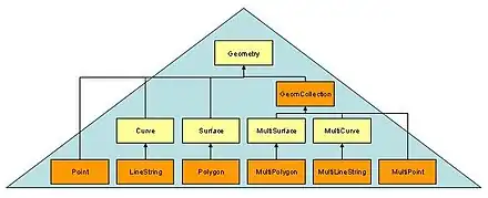
On distingue cinq types de champs[1] :
- CircularString
- CompoundCurve
- LineString
- Point
- Polygon
 Point
Point MultiPoint
 LineString
 MultiLineString
 Polygon
 MultiPolygon
 GeometryCollection
Et 11 types de relations entre eux[2] :
- STEquals
- STDisjoint
- STIntersects
- STTouches
- STOverlaps
- STCrosses
- STWithin
- STContains
- STOverlaps
- STRelate
- STDistance
Requêtes
CREATE TABLE Districts
( DistrictId int IDENTITY (1,1),
DistrictName nvarchar(20),
DistrictGeo geometry);
GO

CREATE TABLE Streets
( StreetId int IDENTITY (1,1),
StreetName nvarchar(20),
StreetGeo geometry);
GO

INSERT INTO Districts (DistrictName, DistrictGeo)
VALUES ('Downtown',
geometry::STGeomFromText
('POLYGON ((0 0, 150 0, 150 150, 0 150, 0 0))', 0));

INSERT INTO Districts (DistrictName, DistrictGeo)
VALUES ('Green Park',
geometry::STGeomFromText
('POLYGON ((300 0, 150 0, 150 150, 300 150, 300 0))', 0));

INSERT INTO Districts (DistrictName, DistrictGeo)
VALUES ('Harborside',
geometry::STGeomFromText
('POLYGON ((150 0, 300 0, 300 300, 150 300, 150 0))', 0));

INSERT INTO Streets (StreetName, StreetGeo)
VALUES ('First Avenue',
geometry::STGeomFromText
('LINESTRING (100 100, 20 180, 180 180)', 0))
GO

INSERT INTO Streets (StreetName, StreetGeo)
VALUES ('Mercator Street',
geometry::STGeomFromText
('LINESTRING (300 300, 300 150, 50 51)', 0))
GO
SELECT ...
Références
Cet article est issu de Wikibooks. Le texte est sous licence Creative Commons – Attribution – Partage à l’identique. Des conditions supplémentaires peuvent s’appliquer aux fichiers multimédias.